|
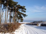
31 January 2009 - Druridge Bay Beach and Nature Reserve Walk, Northumberland.
This afternoon we walked along the beach at Druridge bay and returned via Ladyburn Lake and the track behind the dunes that leads south to Cresswell. It was a very cold day with a strong wind whipping up the sea. There were a few people about and the cafe at Ladyburn Lake Visitor Centre seemed to be doing a good trade.
The first two photos below are views from the dunes, followed by two photos of the beach with a few dog walkers. The next photo is a view of some Highland Cattle that are kept in a field behind the dunes overlooking one of the lakes which can be seen in the last photo.
|

Dunes at Druridge Bay.

Druridge Bay beach.

Druridge Bay beach.

Druridge Bay beach.

Druridge Bay Nature Reserve.

Druridge Bay Nature Reserve.
|
28 January 2009 - East Cramlington Nature Reserve Walk, Northumberland.
This afternoon we visited East Cramlington Nature Reserve, which is located between Cramlington and Seaton Delaval in south east Northumberland. The nature reserve was once an opencast mine and is a pleasant place for a short walk if you are in the area.
Below are some photos of the pond and the track around the nature reserve as well as the giant pylons that run through it.
|

East Cramlington Nature Reserve.

East Cramlington Nature Reserve.

East Cramlington Nature Reserve.

East Cramlington Nature Reserve.

East Cramlington Nature Reserve.

East Cramlington Nature Reserve.
|
22 January 2009 - Bothal, Northumberland.
This afternoon we walked to Bothal under bright blue skies. Crops in the fields seemed to be growing well and looking greener than our last visit on new Year's Day.
Below are two views we have taken often from the roadside looking across the fields towards the farm.
The third photo is a view looking up the fields from near Bothal Village and the last photo is a view of Bothal Castle.
|

View across fields near Bothal.

View across fields near Bothal.

View across fields near Bothal.

Bothal Castle.
|
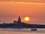
18 January 2009 - Amble, Northumberland.
We visited Amble today for the first time this year for a walk around the harbour. Although it was early afternoon most of the market had packed up and there were very few people about. Just as well because shortly after we arrived heavy rain swiftly moved in from the Alnwick area.
The first three photos below are views across the quayside and River Coquet, with the dark skies approaching from the west. The fourth photo is a view of the lighthouse just before the rain arrived. The last photo is a view along the breakwater just as the rain clouds arrived overhead. That was the last photo of a very short walk.
|

Amble Quayside.

Amble Quayside.

View across the River Coquet.

Amble Lighthouse.

Amble breakwater.
|
16 January 2009 - River Wansbeck Walk, North Seaton, Northumberland.
This afternoon we went for a walk along the River Wansbeck to North Seaton where the old colliery rows used to run down to the boat jetties in the river, all now long gone.
The first three photos below are views of the "Black Bridge" and some swans looking for a feed. The fourth photo is a view down the river towards the Wansbeck Barrage. The fifth photo is a view looking upstream from the approximate location of the old boat jetties at North Seaton and below it is an old photo of a boat moored there in the early 1960's. The last photo is a view of two tiny ponies nuzzling up to each other in a field beside the river.
|

River Wansbeck, North Seaton.

View of the "Black Bridge" across the River Wansbeck.

Swans on the River Wansbeck at North Seaton.

River Wansbeck, North Seaton.

River Wansbeck, North Seaton.

Fishing boat at the moorings at North Seaton Colliery before the village was demolished.

Ponies beside the River Wansbeck, North Seaton.
|
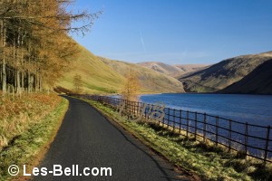
13 January 2009 - Alwinton & Alwin Valley Walk, Cheviot Hills, Northumberland.
Today we went for a walk at Alwinton in the Cheviot Hills in north Northumberland. We walked from Alwinton along Clennell Street (an ancient drove road to Scotland) and followed a path high above the River Alwin towards Kidlandlee. We then descended into the valley and returned along the track that follows the river.
The first photo below is a view of Alwinton and Lords Seat taken from just outside the village. The second and third photos are views from high above the River Alwin looking down into the valley and the track along which we returned. The next three photos show some of the large trucks that travel along this track hauling timber from the forest. The last two photos are views of two very friendly horses near Clennell Hall and four marauding hens looking
for food from walkers in Alwinton car park.
|

Alwinton

View over the River Alwin and Clennell Hall, Alwinton.

View over the River Alwin, Cheviot Hills.

Timber trucks alongside the River Alwin, Cheviot Hills.

Timber trucks alongside the River Alwin, Cheviot Hills.

Timber trucks alongside the River Alwin, Cheviot Hills.

Horses near Clennell Hall, Alwinton.

Hens in the car park at Alwinton.
|
09 January 2009 - Rothley, Harwood and Hartburn, Northumberland.
Today we visited the Rothley and Harwood area to take photos for our Northumberland website. We intended taking photos of the views over Elsdon but cloud and mist put an end to that. Instead we headed back towards Hartburn where we stopped to take photos of the lake at Hartburn Grange.
The first two photos below are views to Rothley West Shield and Dyke Head. The third photo was taken on the road towards Winters Gibbet which is shown in the fourth photo. The fifth photo is a view to Ottercops, a former RAF tracking station and one of the network used in the second world war.
The last two views are from Angerton Lake, a small reservoir at Hartburn Grange.
|

Rothley West Shield

Dyke Head

Harwood Forest

Winters Gibbet

Transmitter masts at Ottercops.

Angerton Lake, a small reservoir between Hartburn Grange and Hartburn Village.

Angerton Lake, a small reservoir between Hartburn Grange and Hartburn Village.
|
03 January 2009 - Blyth South Beach Walk, Northumberland.
Today we visited Blyth South Beach for a walk to the harbour and pier. This beach is very popular with dog walkers and even on a very cold day like today there were many owners out with their dogs enjoying themselves.
The first photo below is a view of the new lifeguard station with gulls circling overhead hoping for some chips from visitors.
The next two photos are views across the beach to the piers and the last two photos are views along the beach towards Seaton Sluice and in the distance St. Mary's Island.
|

Blyth South Beach.

Blyth South Beach.

Blyth South Beach and the piers.

Blyth South Beach looking south.

Blyth South Beach looking south.h
|
01 January 2009 - New Years Day Walk To Bothal, Northumberland.
The New Year started with clear blue skies and brilliant sunshine, in stark contrast to New Years Eve - a very dull day on which to finish 2008.
We walked to Bothal this afternoon and took some photos of the views across the fields between Bothal and Pegswood, which are turning green with new crops as seen in the first three photos. The next two photos are views of Bothal Castle and sheep grazing in the low winter sun.
|

Bothal

Bothal

Bothal

Bothal

Bothal
|
|
Photographers Diary Pages
|
|
|
© Copyright - All photos on this website are
subject to copyright and may not be reproduced on any website or
in print without prior permission. To use any photo please use the
enquiry form at les-bell.com
|