|
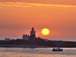
27 February 2009 - Port of Blyth, Northumberland.
This afternoon we visited the Port of Blyth to take a few photos of ships and small boats. Unfortunately there were only a few sunny intervals on an otherwise dull afternoon.
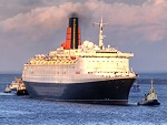
The first three photos below are views across the River Blyth to Battleship Wharf where the cargo ships Cembay and Kielder were moored. The fourth photo is a view down the river to Wimbourne Quay where the container ship Cala Ponente is moored, apparently until 2010. The last two photos are views of the ship from the rear and from across the river at North Blyth.
|

Cargo ship Cembay moored at Battleship Wharf, Port of Blyth.

Cargo ship Cembay moored at Battleship Wharf, Port of Blyth.

Battleship Wharf, Port of Blyth.

Bates Jetties, Port of Blyth.

Container ship Cala Ponente moored at Port of Blyth

Container ship Cala Ponente moored at
|
22 February 2009 - Warkworth Beach Walk, Northumberland.
This afternoon we walked to Amble Breakwater, following the path behind the dunes and returning along the beach.
The first two photos below are views of Warkworth Golf Course and Amble seen from the path to the beach. In the third photo driftwood from the September 2008 floods still litters the path behind the dunes.
The fourth photo is a view of the small beach on the south side of the breakwater followed by a view north along Warkworth Beach. The last photo is a view along the breakwater and the River Coquet to the sea.
|

Warkworth golf course.

Warkworth dunes.

Path to Amble Breakwater.

Warkworth Beach

Warkworth Beach

Amble Breakwater
|
16 February 2009 - Blyth South Beach Walk, Northumberland.
This afternoon we visited Blyth for a walk along the beach to the harbour. The sky was grey but it was still quite bright and the car park was the busiest we have ever seen it.
As well the usual dog walkers there were quite a few people walking on the beach although it never appears busy, as seen in the first photo below. Further along the beach the old pipe was looking as rusty as ever in the second photo. The third photo is a view between the piers and the fourth is a view of the very quiet south harbour where a lot of yachts seem to have left the marina.
The last two photos are views of anglers on the west pier fishing in the extremely calm sea.
|

Blyth South Beach.

Blyth South Beach.

Blyth South Beach.

Blyth South Harbour.

Fishing from Blyth West Pier.

Fishing from Blyth West Pier.
|
13 February 2009 - Coney Garth near Ashington, Northumberland.
Driving past the pond at Coney Garth near Ashington today we saw it was frozen and snow covered and looked as if it would make a good photo. So, we returned with cameras and took some photos from the roadside. This pond, which is on private land, has grown over the years due to mining subsidence. In fact it is now more of a small lake than a pond and is a regular stopping off point for migrating geese as well as being home to swans, ducks, coots and water hens.
The first photo below is a view across the pond towards the nearby farm. In the next two photos the footprints of animals crossing the ice can be seen. The last photo is a view of some geese and other birds around the waters edge.
|

Frozen lake at Coney Garth near Ashington.

Frozen lake at Coney Garth near Ashington.

Frozen lake at Coney Garth near Ashington.

Frozen lake at Coney Garth near Ashington.
|
12 February 2009 - Bothal, Northumberland.
Snow started to fall this morning and became heavier as the day went on. We decided to walk to Bothal and take some photos while it lasted, which is never very long these days.
The first photo below shows the road from Pegswood to Bothal which had a thick covering and was proving tricky for drivers of vehicles other than 4wd, in fact we saw one van stuck on the bank. The next two photos are views of the road into Bothal and the castle. The next photos are views of Bothal Village and the war memorial outside St. Andrews Church.
The last three photos are views of the River Wansbeck and the snow covered stepping stones.
|

Snow covered road between Pegswood and Bothal.

Snow covered road at Bothal.

Bothal Castle.

Bothal Village.

Bothal War Memorial.

Snow covered stepping stones at Bothal.

Snow covered stepping stones at Bothal.

River Wansbeck at Bothal.
|
09 February 2009 - Riverside Walk, Morpeth, Northumberland.
This morning after a light overnight snow shower we were visiting Morpeth on business so we took a compact camera and walked along the riverside.
The bright sun was melting the snow quickly leaving the shady south side of the river contrasting with the sunny north side, as seen in the first view below looking towards Telford Bridge.
The second photo is a view across the river between Telford Bridge and the footbridge. Further along the river in Carlisle Park the tennis courts and bowling greens were both still covered in snow, as seen in the next two photos. The promenade seen in the next photo was also still nice and snowy. The last photo is a view upstream taken from Oldgate Bridge towards the stepping stones.
|

River Wansbeck at Morpeth.

River Wansbeck at Morpeth.

Snow covered tennis courts at Morpeth.

Snow covered bowling greens at Morpeth.

River Wansbeck at Morpeth.

River Wansbeck at Morpeth.
|
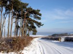
06 February 2009 - Bothal Woods Walk, Northumberland.
This morning after overnight snow we walked to Bothal, then along the River Wansbeck through the woods towards Morpeth. It was a beautiful sunny morning and in the woods the only footprints in the snow were from deer, foxes and rabbits.
The first photo below is a view along the road to Bothal followed by a view across the fields to Bothal Castle. The next two photos are of the weir at Bothal Mill followed by a view of a rope swing over the river a little further upstream. The next photo is a view of the Wansbeck viaduct which carries the main east coast railway to Edinburgh. The last photo is a view of traffic crawling along the Pegswood bypass in the snow.
|

Snow covered fields at Bothal.

Snow covered road and fields at Bothal.

River Wansbeck at Bothal Weir.

River Wansbeck at Bothal Weir.

River Wansbeck at Bothal.

Wansbeck Railway Viaduct

Snow covered road at Pegswood.
|
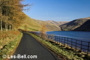
03 February 2009 - River Lyne, Ulgham, Northumberland.
This afternoon we were taking photos in the area around Ulgham, between Longhirst and Widdrington in Northumberland. When we visited Ulgham itself, the River Lyne which flows along the north side of the village, was swollen with rain and melt water. The ford at the west end of the village which is dry most of the time, was submerged under about a foot of strongly flowing water according to the depth markers. Likewise the ford near Ulgham Grange which is always covered
was also about a foot deep.
The first three photos show the west ford and footbridge alongside it and the fourth photo is a view of the ford at Ulgham Grange. The last photo is a view along the path beside the River Lyne near Ulgham Grange.
|

Ford over River Lyne at Ulgham.

Ford over River Lyne at Ulgham.

Bridge over River Lyne at Ulgham.

Ford over River Lyne at Ulgham Grange.

River Lyne at Ulgham.
|
|
Photographers Diary Pages
|
|
|
© Copyright - All photos on this website are
subject to copyright and may not be reproduced on any website or
in print without prior permission. To use any photo please use the
enquiry form at les-bell.com
|