|
28 October 2008 - Blyth South Beach and Harbour, Northumberland.
This afternoon we went for a walk along Blyth south beach where a strong and very cold wind was whipping up the sea, as seen in the first photo below looking south along the beach.
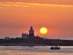
A cargo ship was approaching Blyth, accompanied by the pilot launch and was lurching from side to side as it turned to make it's approach. The second photo shows how far over it was tilting. It was also acting as a giant mirror for the low sun as seen in the third photo.
In the fourth photo someone had planted a dead tree branch next to a fish box and other washed up rubbish, looking like beach art between the piers.
Most fishing boats were tied up in the south harbour but one was returning from the rough sea as seen in the fifth and sixth photos of the harbour and pier.
Back at the beach in the setting sun, big waves were still rolling in as a surfer carefully entered the freezing cold water in the next views. The last photo is a view of the new lifeguard station.
|

Blyth South Beach

Cargo ship approaching Port of Blyth, Northumberland.

Cargo ship approaching Port of Blyth.

Beach Art - Blyth South Beach.

Blyth South Harbour

Fishing boat approaching Blyth West Pier.

Blyth South Beach

Surfer at Blyth South Beach.

Lifeguard station, Blyth South Beach.
|
26 October 2008 - Amble Pier, Northumberland.
We took ;a late afternoon visit to Amble today for a walk around the harbour and pier at sunset. It was cold and there were very few people about. Since our last visit a new navigation light has been erected on the north breakwater, replacing the rusty old structure that has been there for many years.
The first photo below is a view from the end of the pier towards Coquet Island. The second photo is a view of both navigation lights and the third is a closer view of the new light on the north breakwater.
The fourth photo is a view along the pier and the last is a view across the bay with the setting sun reflecting on the windows of Cliff House.
|

Amble Pier

Amble Pier

Amble North Breakwater

Amble Pier

Amble Pier
|
24 October 2008 - Linton Lane Nature Reserve, Northumberland.
This afternoon we visited the nature reserve at Linton Lane near Linton Village, to take photos for our Northumberland website.
This nature reserve consists of two large ponds on a former opencast mine which attract large numbers of wild birds. The ponds are tucked away in a location that most people, other than locals and bird-watchers, probably don't even know about.
Below are four photos of the two ponds and the opencast loading depot which is still in use serving other mines in the area. The last photo shows Linton Lane crossing on the currently mothballed mineral railway line from Ashington.
|

Linton Lane Nature Reserve, Northumberland.

Linton Lane Nature Reserve, Northumberland.

Linton Lane Nature Reserve, Northumberland.

Linton Lane Nature Reserve, Northumberland.

Linton Lane Railway Crossing, Northumberland.
|
21 October 2008 - Bothal, Northumberland.
This afternoon we walked to Bothal in Northumberland in brilliant Autumn sunshine. Down in the valley, sheltered from the cold wind it was very pleasant. Many of the trees here were still green but horse chestnuts and oaks added golden colours to the scenery in this quiet little place.
The first photo below is a view of Bothal Castle with sheep grazing happily in the sunshine. The second photo is a view over recently cropped fields, now being ploughed, as seen in the third photo. The fourth photo is a view across the fields from the road between Bothal and Pegswood. The last photo is a view along the road with the path covered in fallen leaves.
|

Bothal Castle

Bothal

Autumn ploughing at Bothal.

Across the fields at Bothal.

The road to Bothal.
|
16 October 2008 - Mitford Weir, Northumberland.
On our return journey from Nunriding today we passed the weir on the River Wansbeck at Mitford and noticed it had been partly demolished during the recent floods, so we stopped for a photo.
The view below shows a substantial breach in the middle of the weir with large lumps of concrete washed away.
Could these weirs that were built during the industrial revolution now be contributing to some of the floods we see today by restricting the flows of the rivers and keeping them artificially high?
|

Mitford Weir, Northumberland.
|
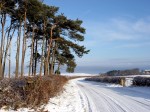
16 October 2008 - Nunriding, Northumberland.
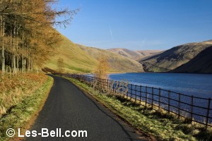
This afternoon we went for a walk at Nunriding in Northumberland. It was a beautiful sunny day and there was plenty of Autumn colour with golden brown horse chestnut trees, red hawthorn berries and rosehips in the hedgerows.
The first photo below is a view of one of the horse chestnut trees with golden bracken in the foreground. The second and third photos are views along the path from Nunriding Hall to Nunriding Moor and the last two photos are views along the narrow road to Nunriding Hall.
|

Nunriding Moor

Nunriding Moor

Nunriding Moor

Nunriding Moor

Nunriding Moor
|
10 October 2008 - Lyne Sands, Northumberland Coast.
After the visual delights of a sunrise and the QE2 arriving at Tynemouth we visited Lyne Sands on the Northumberland coast today.
Without doubt this is the most disgusting stretch of coastline we have ever visited and we will certainly never return. Strewn with rubbish as seen in the first photo below it is an awful place. The other photos are views north and south along the "beach" including Alcan Power Station and the picturesque River Lyne flowing the sea. We will be adding these photos to our Northumberland Beaches website
as a place to avoid.
|

Lyne Sands, Northumberland Coast.

Lyne Sands, Northumberland Coast.

Lyne Sands, Northumberland Coast.

Lyne Sands, Northumberland Coast.

Lyne Sands, Northumberland Coast.
|
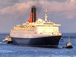
08 October 2008 - Tynemouth - QE2 visit to the River Tyne.
An early start today for a visit to Tynemouth to photograph the arrival of the QE2 on her second and last visit to the River Tyne. Due to arrive at 7am, quite a few people were out and unlike her last visit the great liner sailed straight into the river first time. As the sky glowed with the rising sun the ship made a great sight between the Tyne piers. The first five photos below are views of the QE2 making it's way up the river towards Northumbrian Quay.
Shortly afterwards the sun rose above the low cloud on the horizon to light up the sky and the buildings along the river took on a warm glow as seen in the next two photos. The last two views were taken before the arrival of the QE2 when it was still quite dark.
|

QE2 visit to the River Tyne 08 October 2008.

QE2 visit to the River Tyne 08 October 2008.

QE2 visit to the River Tyne 08 October 2008.

QE2 visit to the River Tyne 08 October 2008.

QE2 visit to the River Tyne 08 October 2008.

Sunrise at Tynemouth.

Early morning view to North Shields.

Waiting for the QE2 at dawn.

Waiting for the QE2 at dawn.
|
08 October 2008 - Tynemouth - ships arriving in the River Tyne.
After the arrival of the QE2 a number of ships arrived in a short space of time, even two at once at one stage when one of the ferries from Holland seemed to be chasing a smaller ship.
The first of these ships seen in the two photos below was the dredger Hedwin, returning after emptying a load at sea. Next in was another dredger the Sand Heron followed swiftly by the ferry Princess of Norway, seen in the next three photos. Shortly afterwards came the bright red liquid tanker, Dutch Pilot which was passed by tugs heading back to the river mouth to wait for another giant ship, the Hoegh Manila. This ship is a vehicle carrier and is seen in the last
four photos dwarfing the Tyne north pier before heading up the river aided by tugs.
|

Dredger arriving in the River Tyne after the QE2 in October 2008.

Dredger arriving in the River Tyne after the QE2 in October 2008.

Ships arriving in the River Tyne after the QE2 in October 2008.

Dredger arriving in the River Tyne after the QE2 in October 2008.

Ferry arriving in the River Tyne after the QE2 in October 2008.

Ships arriving in the River Tyne after the QE2 in October 2008.

Car transporter ship arriving in the River Tyne after the QE2 in October 2008.

Car transporter ship the River Tyne after the QE2 in October 2008.

Car transporter ship arriving in the River Tyne after the QE2 in October 2008.

Car transporter ship arriving in the River Tyne after the QE2 in October 2008.

Car transporter ship arriving in the River Tyne after the QE2 in October 2008.
|
06 October 2008 - Durham City.
Today we visited Durham City to take photos for a new website we are developing. We mainly wanted photos along the River Wear so we walked along the riverside footpath on a lovely sunny morning before visiting the Cathedral and city centre.
The first photo below is a view along the river towards Framwellgate Bridge, followed by two views of Prebends Bridge and Durham Cathedral towers. The next two photos are views of Durham Castle followed by a view through hazy sunshine towards the weir. The last two photos are views to and from Elvet Bridge.
|

River Wear Durham City.

Durham Cathedral

Durham Cathedral

River Wear Durham City.

Durham Castle

River Wear Durham City.

River Wear Durham City.

River Wear Durham City.
|
05 October 2008 - Hauxley Beach Walk, Northumberland Coast.
This afternoon we walked from the north end of Druridge Bay to Hauxley Beach. There were quite a few other people walking on the beach enjoying the bright sunshine.
Just below the cottages at Hauxley was the hull of a small yacht that must have been recently washed up. Bits of it's wreckage were scattered along the beach including a piece of rudder and a sail. Nearby were the remains of a large steel trailer.
The first two photos are views along the beach, which also had more coal dust than usual and kelp washed up by recent heavy seas. The next five photos are views of the yacht and trailer wreckage.
In the last photo a sandcastle, using a rubber glove for it's flag, was glowing in the low sun, but would soon be washed away by the incoming tide.
|

Hauxley Beach

Hauxley Beach

Hauxley Beach

Hauxley Beach

Hauxley Beach

Hauxley Beach

Hauxley Beach

Hauxley Beach
|
03 October 2008 - North Blyth, Northumberland Coast.
This afternoon we visited North Blyth to take photos of the coast. It was a sunny day and the sea was quite rough in the brisk northerly wind and high tide, good conditions for our photography. Waves were breaking over Seaton Sea Rocks on the seaward side of the east pier and over the pier itself, as seen in the first three photos below.
The next two photos are views along the pier taken from beside the Alcan ore terminal and the next is a long view down the coast to St. Mary's Island and beyond to Tynemouth where waves were breaking over the pier.
The seventh photo is a view of one of the River Blyth navigation lights at Seven Stars followed by a view of waves breaking over the sea wall next to it. The final two photos are views of the rough sea beside the wind turbines and along the beach towards Cambois.
|

Blyth East Pier.

Blyth East Pier.

Blyth East Pier.

Blyth East Pier.

Blyth East Pier.

View from North Blyth to St. Mary's Island and Tynemouth.

North Blyth

Waves blasting over the sea wall at North Blyth.

Heavy seas at North Blyth.

Heavy seas at North Blyth.
|
01 October 2008 - Druridge Bay Walk, Northumberland Coast.
This morning we took advantage of bright sunshine to visit Druridge Bay on the Northumberland Coast. We walked through the dunes and along the beach to Ladyburn Lake Country Park, returning along the same route. As usual on weekdays the beach was almost deserted apart from a few walkers and dogs.
The first four photos below are views from the sand dunes where we crossed to the beach with bracken providing Autumn colour. The fifth and sixth photos are views looking north along the almost deserted beach. The next photo is a view of the steps up from the beach to Ladyburn Lake and the last two views are of the visitor centre and lake looking towards the Cheviot Hills.
|

Sand dunes at Druridge Bay.

View from the sand dunes at Druridge Bay.

View from the sand dunes at Druridge Bay.

Sand dunes at Druridge Bay.

View along the beach at Druridge Bay.

View along the beach at Druridge Bay.

Steps up from the beach at Druridge Bay.

Ladyburn Lake and Visitor Centre.

Ladyburn Lake and Cheviot Hills.
|
|
Photographers Diary Pages
|
|
|
© Copyright - All photos on this website are
subject to copyright and may not be reproduced on any website or
in print without prior permission. To use any photo please use the
enquiry form at les-bell.com
|